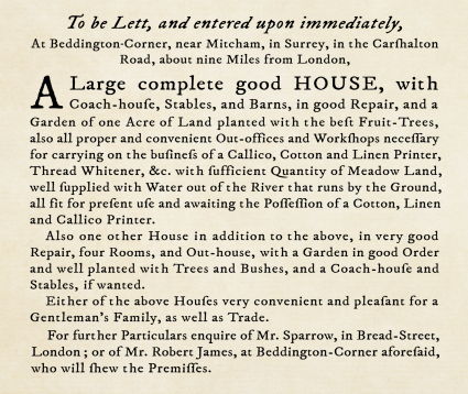
Beddington Corner
Beddington Corner, Sutton/Merton
An assortment of industry, terraced housing and wilderness on the east side of the River Wandle south of Mitcham Common

Although the Beddington Corner name is used to denote the junction of Goat Road, Carshalton Road and London Road (also called Goat Corner), the origin lies in its former location at the north-west corner of Beddington parish.
As the London Encyclopaedia says: “Place naming at this point is indeed very confused, since this part of Beddington became part of Wallington when the parish was formed in 1887; Hackbridge, also with no official existence, merges with Beddington Corner on the south; and the nearby Mitcham Junction station (over the borough boundary) gives a postal district name to this part of the London Borough of Sutton.”
This locality once had watercress beds and market gardens, a sweet-smelling lavender and peppermint distillery and several malodorous leather tanneries beside the River Wandle. The tanneries inspired the names of the (now vanished) Skinners Arms and (extant) Goat public houses.
In the early 19th century a short branch of the horse-drawn Surrey Iron Railway came through Beddington Corner on its way to Hackbridge Mills.
A small combined chapel and national school was built on Mill Green in the 1840s. The structure was demolished after All Saints church was built on London Road in 1931 (almost opposite what is now BedZED) for the newly created parish of Hackbridge and Beddington Corner. The architect was Henry Philip Burke-Downing, who designed several south London churches, most notably St Barnabas Gorringe Park.
Written in 2007, a London Borough of Merton character assessment for the area comments: “Goat Road benefits from eight cottages, one of which incorporates a shop. These properties enhance the ‘village’ feel, and serve as an important buffer to the industrial character of the Willow Lane industrial area at the rear. The character of the remainder of Goat Road is harmed by warehouses and advertising hoardings.”
The acid grassland to the north-east of the Goat public house constitutes the part of Mitcham Common known as the Gunsite, because anti-aircraft batteries were placed here during the Second World War. Mill Green has some woodland that was planted in the early 1990s and two watercourses: a ditch that was once part of a branch of the River Wandle and the Beddington Effluent Carrier, which takes treated effluent from the sewage works to the Wandle. The Mitcham Common Conservators note that: “Although the Carrier is concrete-sided with little wildlife value, the water quality of the treated effluent is much improved in recent years and regular monitoring has shown that it now supports a range of insects and fish.”
Tom Francis and Eric Montague’s book on Old Mitcham tells of a band of Gallician gypsies that once lived in a field near Willow Cottage at Beddington Corner, before departing for America. When the gypsy leader’s daughter died she was buried in Mitcham churchyard with an elaborate funeral, her body bedecked with gold and silver coins.