Canning Town
Canning Town, Newham
A hitherto solidly working-class district – now an ‘emerging area of east London’ – situated north of the Royal Victoria Dock and east of the River Lea
This settlement was originally called Hallsville and probably took its modern name from George Canning, briefly prime minister in 1827 – or from his son Charles Canning, first viceroy of India from 1858 until his death in 1862. Others have suggested that the name came from a mid-19th-century factory, possibly a cannery, but historians have failed to identify the relevant establishment.
The opening of a railway station (initially called Barking Road) in 1847 stimulated early jerry-built development, mostly without proper drainage, leaving the population prone to outbreaks of disease.
The fastest phase of growth came after the 1880s, in the heyday of the Royal Docks. The area’s greatest employer was the Thames Iron Works, Victorian shipbuilders to the world and the original home of West Ham football club. Thirty-eight spectators died at the ironworks when the slipway collapsed at the launch of the warship HMS Albion in 1898.
The last major warship built by the yard was HMS Thunderer in 1911. The following year Thames Ironworks declared bankruptcy and closed down.
The Royal Docks brought significant immigration to the neighbourhood and Canning Town had the largest black population in London by 1920. This was the year that comedy writer Johnny Speight was born here: he went on to create the bigoted television character Alf Garnett.
The area was heavily damaged in the Blitz, leading to the construction of numerous council tower blocks after the war. The partial collapse of the Ronan Point tower block, in the Custom House area, prompted a temporary withdrawal from high-rise solutions to accommodation needs throughout the UK, and beyond. Late-20th-century redevelopment typically took the form of smaller units in a never-ending series of cul-de-sacs, built by housing associations.
Canning Town’s population exhibits a very diverse mix of ethnicities/nationalities. The main groups at the 2011 census are listed in the table below:
| Ethnicity/Nationality | Population | Share of total |
|---|---|---|
| White British | 8,615 | 28.0% |
| Black or Black British: African | 6,043 | 19.6% |
| Asian or Asian British: Bangladeshi | 2,307 | 7.5% |
| White Eastern European (inc. Russian) | 2,098 | 6.8% |
| Mixed ethnicity | 1,747 | 5.7% |
| Black or Black British: Caribbean | 1,437 | 4.7% |
| Asian or Asian British: Indian | 1,282 | 4.2% |
| Asian or Asian British: Pakistani | 840 | 2.7% |
| Asian or Asian British: Chinese | 742 | 2.4% |
| Asian or Asian British: Filipino | 526 | 1.7% |
| Arab | 381 | 1.2% |
| All others | 4,788 | 15.5% |
Poverty and unemployment are high in Canning Town. At Hallsville primary school over three-quarters of the pupils were eligible for free meals at Ofsted’s last inspection – when the school was rated ‘outstanding’.
![Aurelia at Vermilion [developers' CGI image]](https://hidden-london.com/wp-content/uploads/2014/07/Aurelia.png)
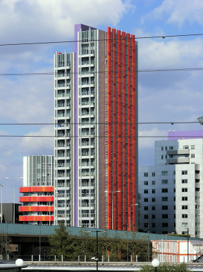
In response to the area’s difficulties (and opportunities), a £3.7 billion regeneration scheme is presently under way, promoted by the London Borough of Newham and encompassing the whole Canning Town and Custom House district.
Some of the older housing stock – including the 23-storey Ferrier Point, has been refurbished, while the most prominent new scheme is the mixed-use development at Rathbone market.
Opposite Canning Town station the redevelopment of what is now being called the Hallsville Quarter will create a new town square with shops, a cinema and hotel and 340 new homes.
In the Fife Road area the Keir Hardie primary school has been rebuilt in conjunction with the construction of new homes at East City Point. Further north, on Hermit Road, Genesis housing association’s Rawalpindi project deserves a mention – if only for its distinctive name.
The comic actors Reg Varney, Windsor Davies and Marty Feldman were all born in Canning Town.
Postal district: E16
Population: 30,806 (Canning Town North and Canning Town South wards, 2011 census)
Station: Jubilee line and Docklands Light Railway (zones 2 and 3)
Further reading: Howard Bloch and Nick Harris, Canning Town, Nonsuch, 2005