Chiswick
Chiswick, Hounslow
A likeable (and accordingly pricy) west London suburb filling the Thames peninsula between Hammersmith and Brentford

Chiswick (pronounced chizzik) grew up as a Thames-side fishing village, sited somewhere very near present-day Chiswick Wharf, shown in the photograph above.* Its name is usually reckoned to have meant ‘farm or trading settlement where cheese is made’ but it is possible instead that the eponymous characteristic here was not cheese but chesil – an old word for shingle (as in Dorset’s Chesil Beach). This spot could therefore have been a ‘shingly trading place’ rather than a cheesy one.
There may have been a pagan shrine here in the 7th century but the first reliable confirmation of the settlement’s existence came in a document written around the year 1000 – when its name was rendered as Ceswican.
In 1181 the village’s name was spelt Chesewic and the presence of St Nicholas’ church was first recorded. The dedication of a church to St Nicholas, patron saint of sailors and fishermen, was common practice where the parishioners’ livelihoods depended on water. The present church dates from the 15th century but it was mostly rebuilt in 1884. St Nicholas’ tower is visible in the top photograph.
The 16th-century Walpole House is the grandest villa on what is now called Chiswick Mall. Though much altered, the house’s imposing façade indicates the status of many of the village’s residents at that time. By the late Middle Ages Chiswick encompassed the hamlets of Little Sutton, Turnham Green and Strand on the Green, across the peninsula.
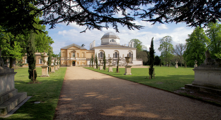
Shown in the photo below, Chiswick House was built in Palladian style by the Earl of Burlington in 1729. Of modest proportions by aristocratic standards, its splendid decor and ornate ceilings have been faithfully restored by English Heritage. Both the house and its estate were enlarged by Burlington’s heirs, the dukes of Devonshire.
William Hogarth acquired a ‘little country box’ close to Chiswick House in 1749 and spent most of each summer here until his death in 1764. Built in the 1710s, Hogarth’s House is now a museum of his life and a gallery of his work. The artist’s tomb, with a poetic epitaph by his friend David Garrick, stands a short distance to the east of the house in St Nicholas’ churchyard.
Building on a centuries-old tradition of ‘Chiswick ales and stout’, the present Griffin Brewery opened in 1828. In the following year wealthy Wiltshire squire John Fuller made his first investment in the business, progressively increasing his stake thereafter. His son brought in outside expertise (and more investment) from two key figures at Romford’s Ind & Smith brewery, signing up to the Fuller, Smith & Turner partnership in 1845. Fuller’s now owns more than 150 pubs in London, with an emphasis on establishments with a bit of character. Its flagship ale is London Pride.
From the second quarter of the 19th century, the orchards and market gardens of the Chiswick peninsula began to fill with housing, much of which was subsumed under the identity of Grove Park. Chiswick New Town was an early project for the working classes, now replaced by council flats. The Glebe estate to its north was more upmarket.
Chiswick station opened in 1849, followed by the now-lost Hammersmith and Chiswick station in 1857 and then Turnham Green and Gunnersbury stations in 1869.
On Chiswick’s northern edge, Bedford Park set a new standard for suburban housing after 1875. By this time Turnham Green had become the commercial heart of Chiswick. Before the end of the 19th century developers had begun to demolish large villas and replace them with mansion blocks or smaller, more densely packed houses.
Acton Green & Chiswick Park station opened in 1887 and it became plain Chiswick Park in 1910, thus extending the prestigious ‘Chiswick brand’ far to the north-west of its point of origin.
The Turnham Green area is now synonymous with Chiswick for many Londoners, and Chiswick High Road is popular for its cafés and restaurants, and for the variety of its shops. Chiswick’s riverfront and Strand on the Green are the least changed parts of this mini-conurbation, the former still grand in places, the latter hanging on to quaintness.
In 1971 Erin Pizzey founded Chiswick Women’s Aid at 2 Belmont Terrace, where she set up the world’s first shelter for battered women. This evolved into the campaigning charity Refuge, which has grown to become the UK’s largest provider of specialist domestic violence services.
Postal district: W4
Population: 22,889 (Chiswick Homefields and Riverside wards, 2011 census)
Station: South West Trains (zone 3)
Further reading: Andrew Wilson, Wild About Chiswick, Unity, 2013
and Carolyn & Peter Hammond, Chiswick Through Time, Amberley, 2010
and Gillian Clegg, The Chiswick Book: Past and Present, Historical Publications, 2004 (a little encyclopaedia of Chiswick)
Website: Chiswick W4
See also: Chiswick Eyot