College Park
College Park, Hammersmith & Fulham
A late Victorian urban village in the far north of the borough, tucked between the railway line and the western end of the Harrow Road

There was never a college in College Park: the name derives from Oxford’s All Souls College, which used to own the land. (The college still owns land in Harlesden, Willesden and Kensal Rise, but not in College Park, it seems. See the map on this page at Who Owns England.)
The area’s development during the last quarter of the 19th century was stimulated by activity on both sides. To the east, Kensal Green had been built up following the success of its cemetery. To the west, Willesden Junction station had opened in 1866.
At the corner of Kenmont Gardens and Valliere Road, Kenmont Gardens school (now Kenmont primary school) was built for the London School Board in 1883. Nikolaus Pevsner describes the structure as “a romantically asymmetrical three-storey composition with battlements and turret.” Nowadays the school has three main community languages: English, Portuguese and Somali.
The Mayhew animal home at the corner of Ponsard Road and Trenmar Gardens occupies the former site of the Christ Church mission to College Park.
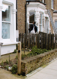
College Park has a high population turnover and a wide variety of ethnic minorities. It also has characteristics that have made it ripe for gentrification, so it now presents contrasting aspects: many properties have been done up while a dwindling proportion remain run-down; there are smart new live/work units on Waldo Road and tatty shops along Harrow Road.
Located at the corner of Scrubs Lane and Harrow Road, the College Park hotel was a local landmark. It closed in the early 1990s and has since been converted into flats.
Postal district: NW10
Population: 9,175 (ward of College Park and Old Oak, 2011 census)
Further reading: Exceptional Wikipedia article on College Park (primarily the work of one knowledgeable person)