East Village
East Village, Newham
The 2012 Olympics athletes’ village, now adapted as a major new residential zone in north Stratford

In the Middle Ages the marshy land here belonged to the Knights Templar, who derived income from watermills beside the River Lea and its tributaries. The area became known as Temple Mills, a name that endured long after the dissolution of the crusaders’ order in 1312.
The surviving mills were demolished in the latter part of the 19th century, when the Great Eastern wagon works were moved northwards here from Stratford. By the late 1950s this had become the biggest railway works in Britain. The principal occupants of the meadows beyond the rail yards were a pair of ‘artificial manure works’.
British Rail added a Freightliner terminal in the 1970s, by which time the entire area now occupied by East Village had filled with engineeering works and depots, sheds, sidings and warehouses, with dozens of railway lines connecting them.
The railway industry progressively withdrew from Temple Mills over the closing years of the 20th century and the property developer Chelsfield devised a £4 billion scheme to create a ‘major metropolitan centre’ called Stratford City on the vacant site, with a shopping and leisure zone and thousands of homes and associated amenities.
Outline planning permission for the scheme was granted early in 2005 but everything changed a few months later when the International Olympic Committee approved London’s bid to host the 2012 summer Olympics, with purpose-built venues to be located in the Lower Lea Valley, north-west of Stratford.
Stratford International station opened in 2009 and gained a Docklands Light Railway connection two years later. The southern part of the Stratford City site was developed as a Westfield shopping mall, which opened in September 2011. The residential project that had been proposed for the larger, northern sector was replanned as the Olympic athletes’ village.
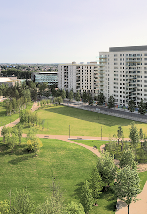
The athletes’ apartments and the surrounding environment have since been remodelled as the new township of East Village.
Completed in late 2013, the ‘village’ has 2,818 homes, spread across eleven developments designed by 16 architectural partnerships and mostly consisting of sets of eight-to-twelve storey blocks built around courtyards.
The complex financial and legal history of the project (which is too messy to chronicle in this article) has resulted in an unusual division of tenure here. Just under half the homes were classified as ‘affordable’ and have been sold or rented by Triathlon Homes under the conditions applicable to such schemes. The remainder of the homes were made available by Get Living London for private rental, but not for sale.
There’s an emphasis on green living (low CO2 emissions, water recycling, lots of spaces for bicycle parking, etc.) and on greenery in the surroundings, with five park areas and 3,000 newly planted trees, including an orchard with apples, plums and pears that residents can pick.
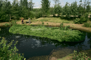
All the apartment buildings have ‘living roofs’, designed to encourage wildlife. On the west side of the village, the Waterglades is a 6‑acre area with ponds and swamps, created as a habitat for native biodiversity.
Local amenities include shops and cafés, a health centre and Chobham academy, which opened in September 2013 and will ultimately cater for 1,800 students aged 3 to 19 years.
To the north of East Village, Taylor Wimpey is presently building a new neighbourhood called Chobham Manor E20. When completed it will consist of around 850 homes, community facilities, shops and 1,500 square metres of publicly accessible open space. The L&Q housing association is responsible for the development’s shared ownership properties.
Postal district: E20
Website: East Village London