Honor Oak Park
Honor Oak Park, Lewisham
Honor Oak’s south-eastern neighbourhood, situated between Brockley’s Crofton Park locality and Forest Hill – and often considered to be part of one or other of those places

There was nothing here but fields bordered by intermittent trees until the Croydon canal meandered through in the early years of the 19th century. The only east-west track across the area was St German’s Road (later renamed Honor Oak Park), which connected with the only north-south route, Brockley Lane (now Brockley Rise).
The Croydon canal was never profitable and it closed in 1836. Three years later, the London and Croydon Railway opened, passing through the Brockley Cutting on a straightened version of the canal’s route. In 1846 the L&CR merged with other railways to form the London Brighton and South Coast Railway. However, no station was at that time provided in this locale.
To the south, much of Forest Hill was built up by the 1850s, but its extent stopped abruptly at Ewart Road, now Ewart Road and Firs Close (at the bottom of the satellite map below).
The Anglican church of St Augustine was built on One Tree Hill in 1872–3, using Kentish ragstone. The church’s Gothic Revival design was the work of the London-based architect William Oakley. The tower was completed in 1888. As Basil Clarke says in Parish Churches of London, and Historic England repeats in its grade II list entry for St Augustine’s, “The church stands in a fine position [almost] at the top of a wooded hill, its design enhanced by the picturesque setting.”
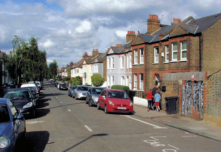
The area’s housebuilders contributed £1,000 towards the cost of constructing Honor Oak Park station, which opened in 1886. Devonshire Road, Lessing Street and Wyleu Street were among the earliest streets to be lined with terraced homes. Several more followed within a decade, including the southern half of Grierson Road, which is shown in the photograph at the top of this article.*
A Wesleyan Methodist church was built on Brockley Rise, at the corner of Ackroyd Road, and the Chandos Arms public house opened on the corner of Codrington Hill. The latter survives, as the Chandos. The last vestige of the old canal did not disappear until the turn of the century, when Boveney Road was laid out. The streets north of Riseldine Road were not built up until after the First World War.
Several sites in the area have been redeveloped in recent decades, most interestingly at Segal Close, to the south-east, and Walter’s Way, to the west. These are both named after Walter Segal, who pioneered low-cost low-skill construction methods ideally suited to self-build projects. Lewisham council supported the schemes, which served as a model that was subsequently adopted by several other English councils, if only for a while.
Faced with a dwindling congregation and the need for expensive repairs, St Augustine’s closed for worship in 2001 but the priest-in-charge at Holy Trinity, Sydenham, succeeded in his efforts to reopen the church two years later – and essential maintenance work has since been done.
Incidentally, St Augustine’s parish covers most of Honor Oak but does not extend east of the railway line, where the northern streets are in the parish of St Hilda with St Cyprian, Crofton Park, and the southern ones are in the parish of St Saviour, Brockley Hill.
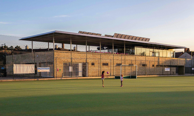
East of Brockley Rise, Guy’s Hospital’s former sports ground is now King’s College London’s Honor Oak Park amenity, also available for hire. Monies raised from the college’s sale of a ground in Surrey to Chelsea football club helped fund a £4m upgrade of the facilities here, including the replacement in 2013 of the old clubhouse with a new pavilion, shown in LTS Architects’ image above.
London Overground assumed responsibility for Honor Oak Park station in 2009, in preparation for the arrival of its services the following year, on the extended East London line.
Wells’ fireworks were made in Honor Oak Park from 1878 until 1947. The factory was located immediately north-west of the station.
Postal districts: SE23
Station: London Overground and Southern (zone 3)

