Leamouth
Leamouth, Tower Hamlets
An isolated pair of peninsulas formed by the meanderings of the River Lea (here called Bow Creek) as it approaches the River Thames

Although there are records of ships being unloaded here as early as 1297, there was little human activity besides some farming and fishing until the late 16th century, when a house was built, with an orchard and a moat. A second incarnation of the house became a pub early in the 18th century.
The creation of the East India Dock in 1803–6 made road access to Leamouth even more difficult but encouraged industrial development and the construction of homes for workers. The northern peninsula – known at first as Godelockhope and later as Goodluck Hope* – was home to a plate glass factory from the 1830s and subsequently to a galvanised ironworks.
Orchard House remained a licensed premises until the 1860s, with ancillary buildings including a bakehouse and a cowhouse, and a skittle ground in front of the premises. The pub was demolished in the early 1870s, after a survey had reported that it was “in such an utterly tumble down condition that there is no alteration except to pull it down,” and its site was turned into a boatyard.
By the late 19th century the vicinity of Orchard Place had become “a deprived area, inhabited by rough, very poor people, living in overcrowded conditions,” according to the Survey of London: Poplar, Blackwall and Isle of Dogs. “Largely cut off from outside influences … this was a closed and closely knit community, inward-looking and inbred, or as the LCC Education Officer politely put it, ‘many families have the same rather uncommon names’.” Almost all Leamouth’s homes and shops were demolished in a slum clearance project in the mid- to late 1930s – and some 300 intimately related residents were moved out of the area.
Galvanised iron manufacture continued at Goodluck Hope until the 1960s, when a vegetable oil refinery took possession of nearly all the peninsula. The refinery operated until the early 21st century.
West of Goodluck Hope, the Bow Creek ecology park (previously the Limmo Peninsula ecological park) is a wildlife haven occupying a former industrial site. Large areas of mud are exposed at low tide, attracting flocks of wading birds.
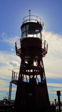
Leamouth’s most enduring employer was the Corporation of Trinity House, the body established in the 16th century to maintain beacons, marks and signs of the sea “for the better navigation of the coasts of England.” From 1803 to 1988 the corporation’s Thames-side workshop occupied the tip of the eastern peninsula, making and deploying navigation buoys and sea marks, and later also testing maritime lighting equipment and training lighthouse keepers.
The corporation’s Trinity Buoy Wharf is now a centre for arts and community projects (some operating from colourfully converted shipping containers), while the restored chainstore – complete with London’s only lighthouse – hosts leisure and cultural events. There’s also an American-style diner and a container-based café. Founded in 2009, Faraday is an independent primary school located at the north-east corner of Trinity Buoy Wharf.
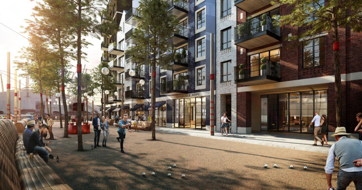
Since 2015 almost all of Leamouth’s two peninsulas except for Trinity Buoy Wharf have been regenerated by the Ballymore Group, a Dublin-based international property development company. Goodluck Hope has become London City Island, while the development on the eastern peninsula (shown in Ballymore’s CGI above) has – oddly – been named Goodluck Hope. Still, it’s nice that this quaint old name is being kept alive, even if it’s in the wrong place. The English National Ballet and the London Film School have been persuaded to relocate to what the developers are calling a “mini-Manhattan on Leamouth Peninsula.” It’s all a far cry from inbreeding and galvanised iron.