Poverest
Poverest, Bromley
The western side of St Mary Cray, north of Orpington

The remains of Romano-British villas and a bathhouse have been uncovered between Poverest Road and Bellefield Road, and are now protected inside a glorified shed (and viewable from outside it). The bathhouse was in use from around ad270 to ad400 and probably served a small farmstead that extended southwards. An Anglo-Saxon burial ground to the north and east of the bathhouse was in use between the mid-fifth and sixth centuries.
Margaret de Pouery owned a manorial estate here in 1327 and the locality’s name is a corruption of hers, via the form ‘Poverish’ in the 19th century, when the vicinity remained wholly agricultural.
Terraced cottages were built to house workers of the paper mills beside the River Cray and micro-localities gained colourful nicknames like Sloper’s Island and Dipper’s Slip.
The Fordcroft estate was laid out from 1882, with plots for 217 homes and a tavern, although most of the homes were never built and the tavern opened as a grocer’s instead.
In 1892 Orpington Baptist church opened the Fordcroft mission hall, which is now in community ownership as Poverest Coronation Hall.
The first council houses were built immediately after the First World War and a flurry of residential development followed the construction of the Orpington bypass (Cray Avenue) in the mid-1920s.
New roads were given names inspired by the presence of a spinney called Robin Hood Shaw and shops were built on Marion Crescent. Commercial enterprises tended to consist of businesses such as scrapyards, coal merchants, hauliers and demolition specialists.
In the late 1950s Orpington council compulsorily purchased most of the houses on the Fordcroft estate and rehoused the residents in Ramsden. Unusually, much of the area that was cleared was left as open space – but this may have been a consequence of inertia rather than a considered decision not to redevelop the sites.
A former raspberry field became Poverest recreation ground (also known as Poverest Park) and Bromley council acquired the neighbouring Covet Wood in 1991.
Local shops have faced the usual difficulties as a result of competition from nearby superstores and Poverest Road post office closed in 2004.
At its 2013 inspection, Ofsted judged Poverest primary school to require improvement in several areas. The school then underwent a complete change of senior leadership and was rated ‘good’ on its next inspections, in 2014 and 2018.
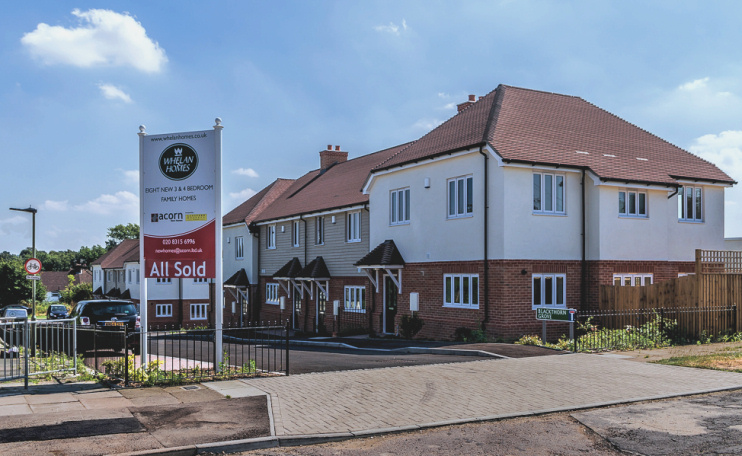
In 2016 Whelan Homes built eight houses in a corner of the grounds of a Thames Water pumping station. Shown in the photograph above,* the properties line one side of the newly created Blackthorn Grove. Bellefield Road also has recently built houses while Marion Crescent has “a stunning collection of brand new one and two bedroom contemporary apartments.”