Stratford
Stratford, Newham
An up-and-coming commercial and residential centre situated north-west of West Ham, of which it was once a part

Cistercian monks founded Langthorne Abbey in the marshes near the River Lea in 1135 and it became one of the richest religious houses in England. The village that grew up east of a ford across the Lea was known as Stratford Abbei or Stratford Langthorne to distinguish it from Stratford atte Bow, on the other side of the river. It was also called Stratford Hamme – a reference to its inclusion within what became the parish of West Ham.
The construction of Bow Bridge attracted early agricultural industry. The village became a centre for the slaughter of livestock brought from East Anglia and for baking bread, using corn ground at the riverside mills on Stratford Marsh – such as the one that gave its name to Pudding Mill Lane.
From the 18th century efforts were made to unite some of the channels of the River Lea that criss-crossed the marsh, notably via the creation of the Lee Navigation.* This reduced the number of crossing points required along Stratford Causeway, now the south-western end of the High Street.
In 1844 (the year the poet Gerard Manley Hopkins was born here) the Metropolitan Building Act forced noxious industries to move outside London – and Stratford was the first place across the border in Essex, with good road and water connections into the city. Existing mills, distilleries and breweries were joined by engineering works, printers, ink and dye works and every kind of processor of coal, oil, manure and animal bones.
George Hudson established the Eastern Counties Railway’s locomotive works here in 1847 and railway workers’ housing was built at what became known as Stratford New Town. From 1867 the Carpenters’ Company began to develop the land it held around present-day Carpenters Road with a mix of factories and housing.
The town centre was built up with shops, public houses, places of entertainment and municipal institutions in the late 19th and early 20th centuries. The best surviving examples from this period are on the south side of the Broadway.
Over the course of the 20th century a mish-mash of utilities, warehouses, yards and scrapheaps filled most of Stratford Marsh, while diverse natural habitats flourished by the waters’ edges.
In 1965 Stratford became the seat of government for the newly created borough of Newham, and the council soon set about demolishing much of the old town and replacing it with a lacklustre shopping centre and municipal tower blocks.
More sympathetic regeneration around the turn of the 21st century brought an almost metropolitan style to parts of the town centre, especially around the compact cultural quarter, which has the Theatre Royal Stratford East and the Stratford East Picturehouse.
Elsewhere in the district, signs of gentrification were already evident when London’s successful bid to host the Olympic Games heralded the complete transformation of the Lower Lea Valley.
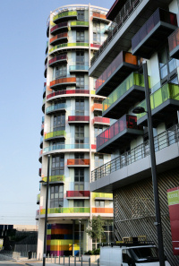
Among the most distinctive new residential developments are Stratford Halo (if only for its 43-storey height) and Telford Homes’ Icona (shown above), with elevations inspired by the work of Donald Judd. Even the down-at-heel Maryland locality has gained a sprinkling of upmarket apartment blocks.
The first trains arrived at Stratford International station in 2009 and the neighbouring Westfield Stratford City became London’s largest shopping mall when it opened in 2011. Stratford is now one of the ten busiest mainline stations in Britain, with more passenger exits and entries than the termini at Fenchurch Street, Marylebone or even St Pancras. It’s also one of the ten busiest tube stations.
Stratford’s property values saw some of the biggest increases in London in the early 21st century and its appeal has continued to grow with the opening of the Queen Elizabeth Olympic Park, the launch of East Village and the proposed redevelopment of the Carpenters’ Estate.