Sydenham
Sydenham, Lewisham (with parts in Bromley and Southwark)
A formerly grand Victorian suburb situated south of Dulwich and Forest Hill

This was Chipeham in 1206, probably the farmstead of a man called Cippa, and the name evolved in stages over several centuries. The last change, when the ‘p’ became a ‘d’, did not occur until the late 17th century.
By this time two distinct settlements had evolved: one around Bell Green in present-day Lower Sydenham and the other in what is now Sydenham Wells Park, where the presence of springs with alleged medicinal qualities was drawing visitors. These two halves of Sydenham were subsequently divided by the Croydon Canal, which was constructed from 1801, and by Westwood Common, which was enclosed in the 1810s.
When the canal company went bankrupt, a railway line was laid along the course of the filled-in canal and Sydenham station opened in 1839, after which houses for wealthy Londoners began to appear on the former common.
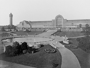
In 1854 the Crystal Palace was brought from Hyde Park and rebuilt on the southern ridge of Sydenham Hill in the south-west corner of the district. This event transmuted the fortunes of the extended village. Improvements in communications made Sydenham the best connected place south of the Thames. Hotels and every kind of amenity catered to the needs of the tens of thousands of tourists. Grand houses were built for the new residents, including Crystal Palace managers and directors, in Upper Sydenham and Lawrie Park, with attendant accommodation for those who provided their services or laboured less lucratively at the palace.
A huge gasworks was constructed at Bell Green, which became one of the most densely built-up parts of outer London. Sydenham’s population doubled every ten years in the three decades to 1871 and doubled again over the remainder of the 19th century, reaching around 40,000.
The appeal of the Crystal Palace declined in the 20th century but its destruction by fire in 1936 was still a tremendous blow. Many of Sydenham’s grandest houses were replaced by homes for the new breed of commuter, while municipal estates were built in several corners, for example at Sheenewood in Lawrie Park, High Level Drive in Upper Sydenham, the Dacres estate in Lower Sydenham, in the Kirkdale area north of Sydenham station, and at Bell Green. On Dartmouth Road, Sydenham School was greatly enlarged to become a comprehensive in 1957.
Despite the changes, the hilly terrain and surviving vestiges of its Victorian heyday continue to endow Sydenham with a distinctive character, although the town centre has long been in need of some form of regeneration – and the form this is beginning to take is the replacement of surplus shops with compact blocks of private flats.
The Antarctic explorer Sir Ernest Shackleton lived at 12 Westwood Hill.
Postal district: SE26
Population: 15,605 (Lewisham’s Sydenham ward, 2011 census; however, the southermost part of Sydenham, including Crystal Palace Park and Lower Sydenham station, falls within the borough of Bromley while the westernmost part, including Sydenham Hill station, is in Southwark)
Station: Southern (zone 3)
Further reading: Steve Grindlay, Sydenham and Forest Hill Through Time, Amberley, 2014
and Joan P Alcock, Sydenham and Forest Hill: History and Guide, Tempus, 2005
Websites: Sydenham Town and the Sydenham Society