Westway
Westway, Westminster/Kensington & Chelsea/Hammersmith & Fulham
The part of the A40 dual carriageway that runs from East Acton to Paddington
Begun in 1964, the Westway was conceived as a solution to congestion caused by the absence of a link between central London and the interwar Western Avenue.
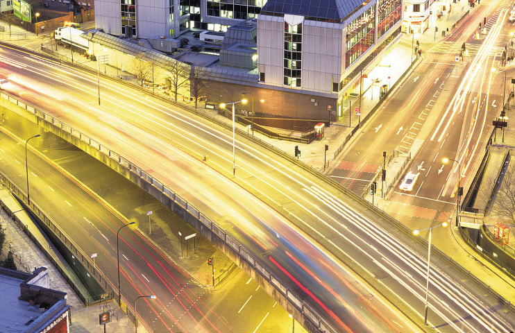
Although the Westway begins where the Western Avenue finishes – at Savoy Circus in East Acton – its name is most often used to refer to the two-and-a-half mile elevated section that runs from White City to Paddington, where it funnels into the Marylebone Road via the Marylebone flyover. The photograph above shows the view of the flyover from the top of Paddington Green police station.* The elevated section of the Westway is shown on the map below.
The Greater London Council forced this state-of-the-art highway through the North Kensington area amidst allegations of Soviet-style disregard for the effects on the local population. Angry protests greeted Michael Heseltine, then Parliamentary Under-Secretary for Transport, when he opened the Westway in July 1970, and the GLC was forced to rehouse some residents living adjacent to the road.
Beneath its elevated section the Westway Project added artistic embellishments and the North Kensington Amenity Trust (now the Westway Trust) helped to establish leisure and cultural amenities.
The road’s bleak underbelly has frequently featured as a film and pop video location, and punk rockers the Clash and the Jam employed Westway imagery. The Clash’s Joe Strummer used to busk in the pedestrian underpass beneath the Marylebone flyover. The subway was named in his honour in 2009.
The Westway provides the setting for JG Ballard’s novel Concrete Island. Ballard compared the Westway with Cambodia’s temple city Angkor Wat, calling it “a stone dream that will never awake.”