Whitechapel
Whitechapel, Tower Hamlets
A historic East End melting pot, situated east of Aldgate

The church of St Mary Matfelon was founded some time in the 13th century and it became known as alba capella or the white chapel. Around 1350 St Mary’s became a parish church – although it survived only a few decades more before being rebuilt – and Whitechapel was the name given to the parish.
The process of industrialisation began locally in the late 15th century with the establishment of construction trades – brick- and tile-making, lime-burning and woodworking – accompanied by what John Stow later called the “building of filthy cottages.”
Sephardi Jews from Spain and Portugal settled here in the late 17th century, forming the nucleus of a community that would become known as ‘the Jewish East End’. Later, German immigrants established a Lutheran chapel and a Roman Catholic church.
New industries included clothing, sugar refining, brewing and engineering.
Whitechapel Bell Foundry moved here from Houndsditch in 1738. It was here that the hour bell of the Great Clock of Westminster (known as Big Ben) and Philadelphia’s Liberty Bell were cast – as well as the bell for the 2012 Olympic Games opening ceremony. Sadly, the foundry cast its final batch of tower bells on 22 March 2017 and closed soon afterwards.
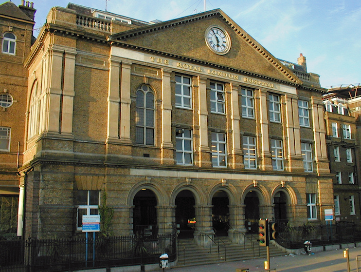
Construction of the London (now Royal London, shown in the photo below) Hospital began on the site of Red Lyon Farm in the 1790s, and it later gained fame for treating the ‘elephant man’, Joseph Merrick. A modest suburb evolved in the neighbouring streets, but many of the houses have since been replaced by ancillary hospital buildings. There’s a museum of the hospital’s history in the former crypt of St Philip’s church.
In the late 18th century Whitechapel produced one of Britain’s most illustrious boxers, Daniel Mendoza, whose fame was so great that he became the first Jew to be permitted to address George III.
Over the course of the 19th century, Whitechapel’s industries lost out to foreign competition while its housing became more overcrowded, especially after an influx of Ashkenazi Jews. One street of 176 houses had 2,516 inhabitants in 1881.
Increasing hardship bred crime and prostitution, and the latter brought the district its enduring notoriety with Jack the Ripper’s murders in 1888. Stories of white slavery may sound like urban myths, but there is well-documented evidence that this trade took place here around the end of the 19th century with local girls being tricked or threatened into working in the brothels of Buenos Aires, Cairo and Constantinople.
Philanthropists worked hard to alleviate conditions, establishing every kind of life-improving institution, from soup kitchens to the Whitechapel Gallery, which is still a major cultural resource for the East End.
Although it has its share of post-1960s monstrosities, Whitechapel was spared the wholesale redevelopment that took place further east after the Second World War, and thus retains enough dark alleys and cramped courts to attract 100,000 participants in Jack the Ripper walking tours every year.
As Whitechapel’s Jews moved to outer north and east London, their place was taken by south Asian immigrants, especially from the 1970s, and two-fifths of the population is now of Bangladeshi origin; 15,000 worshippers attended the inauguration of the London Muslim Centre in 2004.
In advance of the arrival of the Elizabeth line, Tower Hamlets council embarked on a project called Whitechapel Vision, which promised an ‘unprecedented transformation’, though this may have been an exaggeration.
Whitechapel has been the focus of dozens of books, mostly devoted to Jack the Ripper, but Iain Sinclair explored its dark side in a different way in White Chapell, Scarlet Tracings (1987).