Isle of Dogs
Isle of Dogs, Tower Hamlets
An 800-acre tongue of land jutting into the Thames opposite Deptford and Greenwich, now dominated by the gleaming towers of Canary Wharf
The first attempts at draining what was then the ‘marsh of Stebenhithe’ (Stepney marsh) took place in the Middle Ages, when this quagmire was gradually converted to cornfields and pasture. However, several centuries elapsed before reliable protection from flooding permitted the establishment of riverside docks and industry.
By the early 16th century the peninsula was being called the Isle of Dogs – for reasons not known. The most popular explanation is that Henry VIII (or another monarch) kennelled his hunting hounds here – which is credible as Greenwich Palace lay just across the river – but there is no proof of this. Alternative etymologies involve various interpretations of the word ‘dog’ or corruptions of ‘ducks’, ‘dykes’ or ‘doggers’ (fishing boats). In his Dictionary of London Place Names, David Mills devotes a whole page to the subject but reaches no firm conclusion – though his favourite theory is that the name was intended in some way to be “a little facetious, even derogatory.”
The opening of the West India docks in 1802 transformed the northern part of the peninsula – and turned the southern part into something more like a real island. In 1815 two toll roads opened up the hinterland, though it was several decades before many brave (and poor) souls began to set up home here.
William Cubitt built up the south-eastern part of the peninsula in the 1850s, with industry along the riverfront and housing inland. Shortly afterwards, Millwall docks opened – and related industries and dockworkers’ housing filled much of the western half. Large-scale municipal housebuilding projects brought many East Enders here after each of the world wars.
Dock-related activity dominated the Isle of Dogs until the 1970s, when containerisation and the increasing size of cargo ships led to the growth of Tilbury and the coastal ports at the expense of London’s docks. West India and Millwall docks closed in 1980 and the following year their ownership passed from the Port of London Authority to the London Docklands Development Corporation.
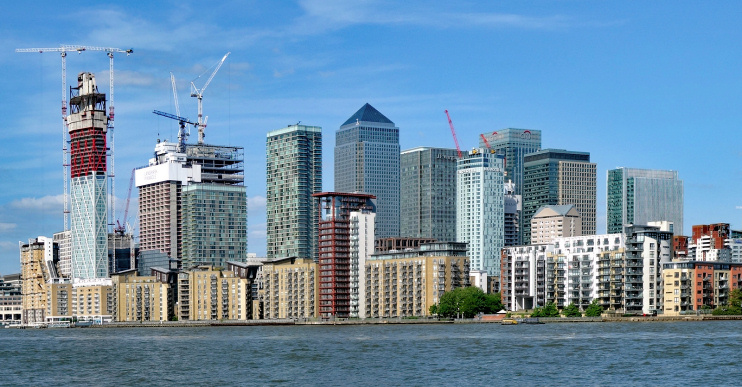
The LDDC’s regeneration mission was a flagship project for Margaret Thatcher’s Conservative government, which relaxed planning controls, granted tax incentives and invested in infrastructure, most visibly in the form of the Docklands Light Railway. The first phase of the DLR opened between Tower Gateway and Island Gardens in 1987. In the same year (after earlier, less ambitious plans had been discarded), construction work began at Canary Wharf – the centrepiece of the whole initiative, shown below in a recent photograph.
During the early 1990s a combination of recession, the ending of the Isle of Dogs’ enterprise status and renewed competition from the City of London halted the commercial property boom. Land values tumbled, whole blocks lay empty and property developers went into liquidation. It was not until the beginning of the 21st century that construction projects regained – and then surpassed – their original momentum.
South-east of Millwall docks, a former silt tip was saved from development and converted to an urban park and city farm. Over to the west, a disused church became The Space, a performing arts and community centre. Elsewhere on the island, almost every available site was eventually pressed into the service of mammon.
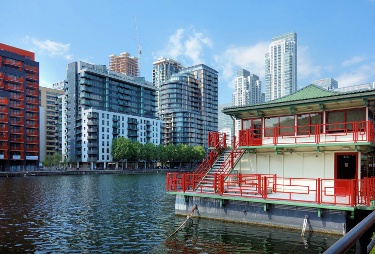
The northern part of the Isle of Dogs now bears more resemblance to the business district of a modern American city than to anywhere else in London, while the south is an amalgam of East End terraces and council flats and upmarket waterfront apartment complexes, including those at Millwall dock, shown (together with a floating Chinese restaurant and supermarket) in the photo at the top of this article.
In 1598 Thomas Nashe and Ben Jonson wrote a seditious play called The Isle of Dogs – but the title may have been a sardonic reference to the whole island of Britain.
Postal district: E14
Population: 42,545 (Millwall and Blackwall & Cubitt Town wards, 2011 census, when these two wards covered the whole of the Isle of Dogs and a little beyond to the north-east)
Further reading: Hermione Hobhouse (editor), Survey of London: Poplar, Blackwall and the Isle of Dogs, the Parish of All Saints v. 43 & 44, Athlone Press, 1999
and Mick Lemmerman, The (Old) Isle of Dogs from A to Z, self-published with CreateSpace, 2014
Blog: Isle of Dogs Life
See also: Westferry, Heron Quays and Crossharbour
* The picture of Red Railings, Milwall Dock, at the top of this page is slightly modified from an original photograph, copyright Des Blenkinsopp. The view of Canary Wharf from Greenland Dock is minimally modified from an original photograph, copyright Julian Osley. The picture of Low cloud over the Isle of Dogs (viewed from the bus station at North Greenwich) shown in search results is adapted from an original photograph, copyright Stephen Craven. All the photos come from Geograph Britain and Ireland and are made available under the Attribution-ShareAlike 2.0 Generic Licence. Any subsequent reuse is freely permitted under the terms of that licence.
Docklands books

