Haydons Road
Haydons Road, Merton
The southernmost section of the A218, which runs from Wandsworth to Merton, west of the River Wandle

The Haydon family had been living in Merton for over two hundred years when George Haydon acquired Cowdrey’s Farm in 1746. The site of the farmhouse is now marked by Cowdrey Road. The track that led to the farm from Merton High Street had been called Cowdrey Lane, but soon became known as Haydons Lane.
In the 1840s Plough Lane branched eastwards off the northern end of Haydons Lane in the direction of the Plough Inn, which lay across the Wandle.
The arrival of the railway in the 1850s brought early suburban development as part of what was initially called New Wimbledon, later South Wimbledon.
The Church of England established a mission in a small room off Haydons Lane in 1859. Around 1870 the lane was renamed Haydons Road and streets of working class housing began to be laid out, like De Burgh Road in the 1870s and Dryden Road in the 1890s.
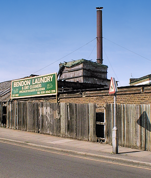
At the corner of Caxton Road, Bendon Laundry was established in 1902 in outbuildings that had originally served as a cowhouse and stable. The laundry was extended in several stages over the following century before its recent demolition to make way for a primarily residential ‘mixed-use scheme’ of the kind that usually replaces disused industrial premises in modern London.
Though sections of Haydons Road retain a low-rent appearance, much of the housing in the hinterland is pleasant enough, and new homes continue to be shoehorned into every available space.
Two women and a man who masterminded a million-pound prostitution ring were jailed in 2003. The team brought unsuspecting Thai women to the UK and set up a brothel at 261a Haydons Road as a ‘training centre’ for them. The women were then sent to work in other brothels outside of the organisation, or were ‘sold on’ to new owners.
Postal district: SW19
Station: Thameslink (zone 3)
