London boroughs map
London boroughs map
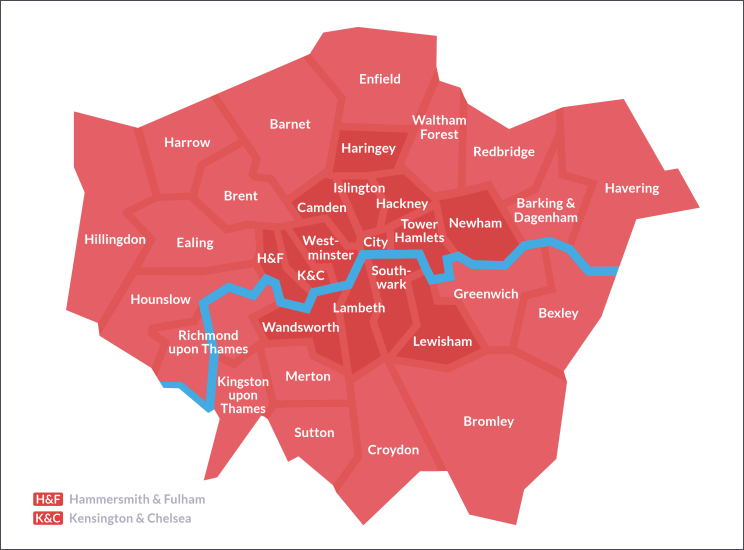
The 32 boroughs of Greater London – plus the City of London

The present boroughs of London were constituted in 1965. Since then there have been many minor boundary changes, of which the most significant were the transfer of Farleigh back to Surrey in 1969 and Barnet’s later loss of the hamlet of Kitt’s End to the Hertfordshire borough of Hertsmere.
Royal boroughs
![]() Kensington and Chelsea, Kingston upon Thames and Greenwich are royal boroughs, the latter since 2012, when it was honoured to mark the diamond jubilee of Elizabeth II in recognition of its many centuries of close association with the Crown. The ‘royal’ appellation is purely honorary, and makes no difference to the borough’s administrative status or governance.
Kensington and Chelsea, Kingston upon Thames and Greenwich are royal boroughs, the latter since 2012, when it was honoured to mark the diamond jubilee of Elizabeth II in recognition of its many centuries of close association with the Crown. The ‘royal’ appellation is purely honorary, and makes no difference to the borough’s administrative status or governance.

The cities of London
![]() Westminster is a city in its own right, as of course is the City of London. The former is also a conventional borough and all its councillors are elected in the usual democratic way. The City of London is a special case – a ‘unique authority’, as it calls itself. Croydon has applied for city status on four occasions, most recently in 2012, when it was yet again unsuccessful, as was Tower Hamlets.
Westminster is a city in its own right, as of course is the City of London. The former is also a conventional borough and all its councillors are elected in the usual democratic way. The City of London is a special case – a ‘unique authority’, as it calls itself. Croydon has applied for city status on four occasions, most recently in 2012, when it was yet again unsuccessful, as was Tower Hamlets.
Inner and Outer London
![]() On the map above, the boroughs of Inner London are tinted darker than those of Outer London. When the Greater London Council was established in 1965, twelve boroughs and the City of London were designated as constituting Inner London. After the demise of the GLC, compilers of official statistics introduced a revised definition that excluded Greenwich and included Haringey and Newham (as tinted on the map).
On the map above, the boroughs of Inner London are tinted darker than those of Outer London. When the Greater London Council was established in 1965, twelve boroughs and the City of London were designated as constituting Inner London. After the demise of the GLC, compilers of official statistics introduced a revised definition that excluded Greenwich and included Haringey and Newham (as tinted on the map).
However, the London councils have stuck with the old categorisation – as does the GLA’s London Plan, except that it has moved Newham from Outer to Inner London.
The Department for Education employs a definition all of its own when calculating ‘weighting allowances’ for teachers’ salaries. The DfE’s idea of Inner London includes every borough that doesn’t touch the outer edge of London – thus incorporating Barking & Dagenham, Brent, Ealing and Merton.
None of these definitions is ideal. The most authentic way to divide Inner London from Outer London would involve drawing the boundary line through several boroughs, but this would obviously bring its own difficulties.
Level 2 of the UK’s Nomenclature of Territorial Units for Statistics divides London into five parts, as shown below.

Online boundary mapping

To see precise borough boundaries in an online street atlas, Hidden London recommends Streetmap.co.uk. The boundaries are shown as thick purple lines in the 1:2500 and 1:5000 views. Streetmap is also good for postal district boundaries, which are shown as thin red lines at the same levels of zoom.
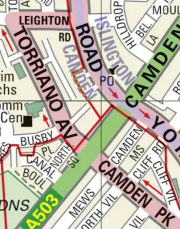
For example, the detail featured here shows the boundary between the boroughs of Camden and Islington (running along the middle of Brecknock Road and York Way), as well as the meeting point of the NW1, NW5 and N7 postal districts.
