Hawley’s Corner
Hawley’s Corner, Bromley
The southernmost and most elevated distinct settlement in Greater London, situated at the junction of five roads, halfway between Biggin Hill and the M25

According to David Mills’s Dictionary of London Place Names, this tiny hamlet was first recorded in the latter part of the 19th century, when it was spelt as Horley’s Corner on one map and Hawley’s Corner on another. Probably named after a local family, it lay at the south-west corner of the parish of Cudham and of the ancient hundred of Ruxley.
Miss Thorneycroft, the daughter of a local farmer, set up a Christian mission in a cottage at Hawley’s Corner in 1877. After the Thorneycrofts moved away and the lease expired a new chapel was established in nearby South Street.
Former tearooms at the apex of Grays Road and Buckhurst Road were extended to become the Spinning Wheel public house, now converted into an Indian restaurant.
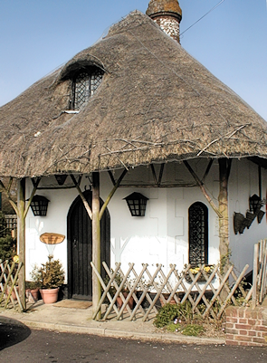
A miniature thatched cottage marooned in the restaurant’s car park may be the cutest little structure in the whole of Greater London. Hidden London is unsure whether or not this was the cottage that accommodated the Christian mission.
The south-western quarter of Hawley’s Corner, which includes Westerham Heights garden centre, was transferred to the care of Sevenoaks district council in 1993. East of Main Road, Broomcocks Wood remains part of London (click here to see the boundary on Streetmap).
Between Broomcocks Wood and the southern end of Main Road the terrain rises gently above the 800 feet and 245 metre contours, making this the highest place in London. It’s labelled as ‘Westerham Heights’ on the map below. Just a few hundred feet to the south-west, Betsom’s Hill is the highest point in Kent, at 823 feet above mean sea level.
Postcode area: Westerham, TN16
Blog post: Diamond Geezer visits Hawley’s Corner
See also: Southernmost point in London
