Coldharbour
Coldharbour, Havering
A remote and isolated Thames promontory situated in south Rainham, across the river from Erith

The promontory here is called Coldharbour Point and its name is probably a reference to the bleakness of the location; a harbour was originally a place of shelter for wayfarers, not necessarily a haven for ships.
Coldharbour’s earliest appearance on a map was around 1560 as ‘Coleherbert’, which was probably a confused spelling. Later maps show Great and Little Coldharbour.
These are concrete barges stranded on the mud here. These were used as part of a Mulberry harbour during the Allied invasion of Normandy in 1944. The barges were utilised to shore up flood defences in 1953 but are now abandoned.
Waste from London is brought up the Thames in barges and deposited in Coldharbour’s hinterland. This locality forms part of Havering Riverside, a zone that could eventually be the site of major commercial and residential developments. However, for at least the next few years, most of the promontory will continue to be used for waste management as Veolia has planning permission to operate here until 2024.
At present, the only significant employer here besides the landfill operator is Tilda, the basmati rice specialist. The company has been based on Coldharbour Lane since the 1980s.
The London Loop is a 150-mile walking route that entirely encircles Greater London. The loop became fully walkable in 2001, beginning at Erith and ending on the opposite bank of the river at Coldharbour Point. It has since been extended through to the RSPB visitor centre beyond the London boundary in Purfleet, making Coldharbour more accessible to the public.
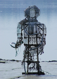
Shown in the photograph above*, The Diver is a sculpture by John Kaufman, inspired by his grandfather’s work as a diver at the London Docks. The Diver is located immediately south of the concrete barges.
Postcode area: Rainham RM13
Web page: TfL walking guide: London Loop – Rainham to Purfleet
See also: Rainham Marshes
