Rippleside
Rippleside, Barking & Dagenham
A commercial locality in south-east Barking, north of the marshland of Ripple Level
In Old English a ‘ripple’ was a strip of land and Ripple Street was in existence here by the 16th century, later becoming Ripple Side before taking its modern form, Ripple Road. A newly created local burial board laid out the 31-acre Rippleside cemetery in 1886.
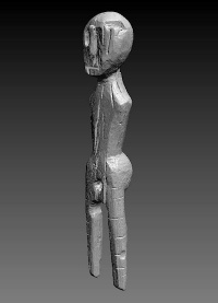
The Dagenham Idol was dug out of the marshes just south of Ripple Road in 1922. Because Dagenham had no museum in which the idol could be displayed it was taken to Colchester Castle Museum, which still owns it. A pinewood figure, radiocarbon dated to c.2250 BC, the idol may have been buried as a talisman to help crops grow – although since its rediscovery it has been rumoured to bring bad luck. The borough nowadays has the excellent Valence House Museum and the idol is presently on indefinite loan here.
Across the dual carriageway from Castle Green, the area is dominated by commercial estates and the rail sidings and depots of the Ripple Lane rail terminal, which is nowadays a major transfer point for European freight.
Ripple Lane is the point of arrival for the first direct train service from China to the UK; which became the world’s second longest railway freight route on its inauguration in January 2017.
South of the railway lie the recent residential developments of Barking Riverside and an ‘urban common’ called the Ripple nature reserve. A range of habitats has developed on this former industrial site now managed by the London Wildlife Trust, with orchids, grass snakes and harvest mice.
Postcode areas: Barking IG11 and Dagenham RM9