West Hampstead
West Hampstead, Camden
A stepping-stone residential area for upwardly mobile young professionals, situated to the south-west of its Hampstead parent between the Finchley Road and Kilburn High Road

Lacking its own supply of spring water and situated away from the main roads, medieval West End (as it was originally known) barely qualified as a hamlet until a few country houses were built here from the 17th century onwards. The tendency for West End Lane to become impassably muddy after heavy rain further enhanced the hamlet’s isolation.
In 1815 West End remained exceptionally quiet – so much so that its inhabitants claimed to have heard the cannon fire at Waterloo. The construction of the Finchley Road brought few additions to a population that consisted of a handful of squires and some farm labourers, gardeners and craftsmen. By 1851 West End had one inn and two beershops.
Railways were the prime stimulus of growth in many country corners of modern London but few places were transformed as wholly as West End. With the arrival of the Hampstead Junction Railway in 1857, the Midland Railway in 1868 and the Metropolitan and St John’s Wood Railway in 1879, the new suburb of West Hampstead spread in all directions.
Some of the new estates were the work of big developers like the United Land Company, whose inclination was to build fairly densely, and during the latter decades of the 19th century parts of West Hampstead became increasingly working-class in character, with policeman, travelling salesmen and railwaymen mixing with clerks and artisans. Engineering workshops operated near the railway lines.
Twentieth-century building was limited mainly to interwar blocks of flats in the north of the district, often in place of Victorian houses that had already become run-down. From the 1940s many Czechs settled here, though most of them subsequently moved further out to the north-western suburbs.
Visible in the 2014 photo at the top of this article, when the building was nearing completion, Nido West Hampstead (as it’s now called) is an accommodation block for 347 students.
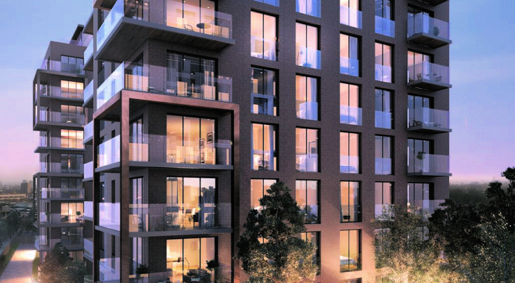
Completed in 2017 and shown in the developer’s CGI below, West Hampstead Square consists of 198 residential units in five blocks squeezed between the railway lines on a site that had previously been occupied by the ramshackle Woodley Park trading estate. Access is via the bizarrely named Heritage Lane. At the eastern end of the development there’s a connected pair of additional blocks with retail, leisure and office space.
The West Hampstead ward now has relatively few families and a great number of young single people. A large proportion of homes are privately rented and fewer than a quarter of adults are married, compared with more than half for the country as a whole. This socio-economic profile is evident in the upmarket cafés and specialist shops that have lined West End Lane in recent years.
West Hampstead residents have included the singers Dusty Springfield, Joan Armatrading, Olivia Newton John and Jimmy Somerville, author Doris Lessing, actresses Imelda Staunton and Emma Thompson, and the playwright Joe Orton, who lived on West End Lane with his lover Kenneth Halliwell from 1951 to 1959.