Corbets Tey
Corbets Tey, Havering
A commuter village located south of Upminster, to which it is now connected by suburban development

The settlement that is now Corbets Tey was first recorded in 1461 – when it was Corbinstye – so there is certainly no truth in the story that Elizabeth I said to her servant, “Corbet, stay and ask the name of this place” – and when she was told that it had no name, decreed that it be called after her first words. Somewhat more likely is that Corbin was the landowner and Tey comes from the Old English ‘tye’ or enclosure.
The medieval manor of Gaynes occupied most of the southern Upminster area and some of its land has been under cultivation for over 2,000 years. On Corbets Tey Road, the rubble-walled tower of Upminster’s parish church of St Laurence dates from the early 13th century.
There was a tannery at Corbets Tey from 1573 to 1635 and gravel extraction took place in the vicinity from the 18th century. The most notable survival at the centre of the old village is High House, a tall farmhouse built around 1700 and still possessing a virtually complete original interior.
During the 1770s Sir James Esdaile commissioned a very grand manor house at Gaynes, with a 100-acre park created from the surrounding farmland – but within about 50 years most of the mansion had to be demolished to make the property affordable to a new buyer. Esdaile also built Harwood Hall in 1782, and its distinctive castellations were added a century later. It is now Oakfields Montessori school.
The surviving east wing of the manor house at Gaynes stood until 1929, when it was pulled down to make way for what the architectural historian Nikolaus Pevsner called “singularly unexciting straight streets of dull houses” – but a small part of the grounds was retained as parkland.
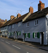
Corbets Tey has some early weatherboarded and half-timbered cottages – notably the lovely group on Harwood Hall Lane, shown here – but these have been overwhelmed by the more recent developments that have surrounded them.
The Corbets Tey gravel formation is a sedimentary layer that may have represented the north bank of the lower Thames during an interglacial phase of the Pleistocene epoch.