Harold Wood
Harold Wood, Havering
A Victorian railway township, now much enlarged and rebuilt, situated just over two miles north and a little to the east of Hornchurch

Harold’s Wood was a large forest stretching far to the north-west of the present district. Although King Harold once owned the estate there is no evidence that he ever visited it. After the trees were cut down in the 15th and 16th centuries the land became known as Harold’s Wood (or Romford) Common. Harold Wood Farm was probably established in the mid-18th century and was later acquired by local grandees the Neave family. The district of Harold Wood grew up some distance away, on 300 acres of Gubbins Farm, following the opening of the station in the late 1860s.
The station was built with the sponsorship of the Harold Wood Estate Company, formed by a group of builders to exploit the potential for residential development here, in the first suburban scheme in the parish of Hornchurch. New roads were laid out and some expensive villas were built, together with the King Harold public house, but neither prosperous nor clerical commuters wanted to live so far out of London and the project foundered.

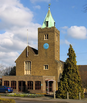
In an indication of the slow pace of the suburb’s evolution, an iron church was provided in 1871 and it was almost 70 years before this was replaced by a permanent structure, St Peter’s church (shown in the photograph on the right). Meanwhile, industrialisation took the form of a brick company and later a provender mill on Gubbins Lane.
In 1908 a Victorian house called the Grange became a children’s convalescent home, which was to form the nucleus of Harold Wood hospital, initially run by the borough of West Ham.
Harold Wood’s rural character finally vanished after the First World War as the district filled with new housing, and Victorian properties were demolished to make way for more affordable dwellings. The brick company’s site was built over in the late 1940s. Unilever acquired the mill in 1965 and its buildings were demolished around 1970.
Harold Wood hospital closed at the end of 2006 and has been replaced by a residential project called Kings Park, an NHS polyclinic and the Havering campus of London South Bank University.
Three-quarters of Harold Wood’s homes are owner-occupied, and 90 per cent of residents are white (down from 95 per cent in 2001).
