Riddlesdown
Riddlesdown, Croydon
Chalk downland in north Kenley, and its neighbouring residential locality

Part of Riddlesdown is a scheduled ancient monument containing Neolithic remains. Saxon graves have been discovered on Riddlesdown Road and their alignment suggests that the route was in use in the seventh century.
Riddlesdown was first mentioned by name in 1277 and derives from Old English and Middle English words meaning ‘cleared woodland on a hill’. The woodland is believed to have consisted of beech trees, which flourish on chalky soil. A quarry that produced lime from the chalk deposits was in existence by the late 18th century.
The Corporation of London acquired the majority of Riddlesdown in 1883, preserving it as open space. The acquisition resolved a dispute between the owner of nearby Little Roke House and the lord of the manor, who had been attempting to encroach on the common land.
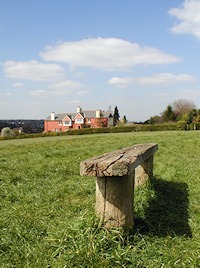
The common’s Metropolitan drinking fountain and cattle trough is visible in the middle distance in the photograph at the top.*
Riddlesdown national school catered for children from Purley and Kenley in the years when the hamlets were first evolving into suburbs. Gardner’s pleasure resort was established in 1892 at the foot of Riddlesdown, and for a while drew day-trippers in their thousands.
Riddlesdown station opened in 1927 and a tunnel carries the railway line southwards beneath the down. The neighbouring area soon filled with some pleasing houses and small parades of shops were built near the station, although only one was occupied ten years later. Developers nevertheless persisted and built another parade in 1939, which proved equally difficult to let.
St Edmund’s church was built on Mitchley Avenue in 1955. It is a hall church, i.e one that is used as a community resource during the week – for activities such as playgroups, badminton and Brownies – but converts into a church when services are to be held.
In 1962 Riddlesdown Residents’ Association successfully defeated an attempt to build six three-storey blocks of flats near the station but the sites were eventually developed in the 1980s.
Located at the south-eastern end of the common, Riddlesdown Quarry closed in the 1960s and is now of regional importance for its geological interest. Access to the quarry is restricted (but not for goats, which roam freely here).
Riddlesdown Collegiate is a voluntary-aided mixed comprehensive and has been accredited as a specialist science college since 2004.
Postcode area: Purley CR8
Station: Southern (zone 6)
Website: Riddlesdown Residents’ Association