Kilburn Park
Kilburn Park, Brent/Westminster
The south-western part of Kilburn, situated between Kilburn High Road and West Kilburn

The area may have been part of Kilburn Abbey’s lands in the Middle Ages but the ‘Park’ element of the name was merely a builders’ invention.
In 1850 the Reverend Edward Stuart sold 47 acres here to a consortium of five developers, of whom the largest was James Bailey. They laid out roads and sewers and divided the site among themselves, subletting to smaller firms who built a few houses each.
Several of the contractors aimed high with their early efforts but the isolated, muddy location failed to attract buyers and the estate remained incomplete for several decades.
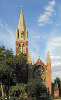
In the absence of middle-class residents, properties were soon subdivided, some containing as many as six households in the 1870s – a time when the Reverend RC Kilpatrick commissioned an extraordinary church for Kilburn Park.
St Augustine’s is one of the most breathtaking Victorian churches in the whole of England, a fusion of French-inspired detailing and Anglo-Catholic tradition, with a soaring steeple. The body of the church was complete by 1877 but it was another 20 years before the spire reached its full height of 254 feet. St Augustine’s has been nicknamed ‘the cathedral of north London’.
Perhaps the church gave Kilburn Park the cachet it had previously lacked, for the remainder of the estate was built up in the late 1880s. The Bakerloo line reached Kilburn Park in 1915.
Much of the area was damaged by Second World War bombing and was afterwards subject to wholesale redevelopment and the addition of several council tower blocks – but St Augustine’s still soars above them.
Nowadays, the vicinity of Kilburn Park and Kilburn High Road stations is frequently referred to as ‘North Maida Vale’, especially by estate agents. Hidden London considers this ridiculous but it is the kind of thing that happens quite often when a locality has a relatively poor reputation but a nearby area has a much more prestigious name.
The cyclist Sir Bradley Wiggins grew up at Dibdin House, a block of 250 working-class flats built in 1937 at the Kilburn end of Maida Vale (visible on the right in the satellite map below). He was educated at St Augustine’s CE high school, where his mother was a secretary.
Postal district: NW6
Station: Bakerloo line (zone 2)