Sutton
Sutton, Sutton
Situated four miles west of Croydon, Sutton has been a busy town since the Victorian era – and its centre is presently undergoing another phase of rapid redevelopment

Domesday Book provided the first reliable mention of the estate, as Sudtone. The name meant ‘south farmstead’ and may have referred to its position in relation to either Morden or Mitcham.
Little is known of Sutton’s form or character in the Middle Ages. It might not even have existed as a focused settlement until much later. By the mid-18th century the village consisted of a loose ribbon of houses along the High Street.
At the first census, in 1801, Sutton had fewer inhabitants than Cheam or Wallington, and far fewer than Carshalton, but an increase in coaching traffic on the Brighton road and the subsequent arrival of the railway in 1847 prompted a phase of rapid growth.
The medieval parish church of St Nicholas was demolished and replaced by the present church in 1864. Soon after this, more railway connections were added and lord of the manor Thomas Alcock developed a prestigious estate that formed the new parish of Benhilton, and endowed All Saints’ church.
Alcock also laid out the streets of Newtown, east of the High Street, but left it to an assortment of builders to put up cramped terraced housing here for the working classes. Shops and several pubs lined Lind Road, but few of the original properties have survived.
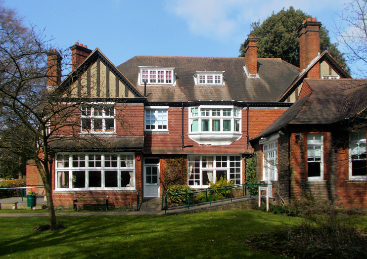
By 1881 Sutton had grown larger than its three rivals combined. Some very grand homes were built in south Sutton towards the end of the century but these too have mostly been replaced by flats or smaller houses. One stately (though not beautiful) survivor on Worcester Road, Russettings, has been preserved as the borough’s register office – and is shown in the photograph above.
The town continued to expand, especially after trams came from Croydon in 1906, but having already grown so much it lacked the space for the kind of Edwardian or interwar development that transformed its neighbours. Visible in the photo at the top of the page, Trinity church was built by the Methodists in 1907 (though it looks almost medieval †).
In 1914 the council created Manor Park from the grounds of three large houses, none of which had ever been a manor house, though one had been named Manor Park House.
The West Sutton and Sutton Common localities filled with compact housing in the 1930s, following the construction of the Sutton bypass and the railway loop line to Wimbledon. In 1934 another architecturally impressive church opened on Cheam Road, providing a new home for Sutton Baptists.
After the Second World War, and especially in the 1960s, much of the old town centre was redeveloped with shops and offices, although not on the scale witnessed in Croydon. Initiatives in the fourth quarter of the 20th century included the pedestrianisation of the High Street and the opening of the multi-use civic centre, the Secombe Theatre (since closed) and the Times Square and St Nicholas shopping centres.
Away from the town centre, developers frequently sought planning permission to demolish sizeable older properties and replace them with small apartment blocks. More recently, some underused office blocks have been replaced by, or converted to, flats.
Major mixed-use developments have affected both ends of the High Street lately (notably at the Old Gasworks site), and Sutton council proposes further radical changes in the years to come. The draft masterplan for Sutton 2031 foresees the town centre becoming “a destination of choice because of its distinctive offer that makes it stand out from its competitors … known for the human scale of its high quality High Street; for its strong local heritage that will have been enhanced and celebrated; for the range of small independent retailers; and the vibrant and bustling range of cultural activity and entertainment for people of all generations supported by a diverse and rich dining offer.”
Aspects of this scenario sound over-optimistic but Hidden London nevertheless applauds the council for at least having a vision – and aiming high.
Two-thirds of Sutton’s residents are of white British origin and a clear majority are categorised within the ABC1 social groups – overwhelmingly so in the Sutton South and Sutton West wards.
The raconteur and pioneer of open effeminacy Quentin Crisp was born in Sutton in 1908. His life was portrayed by John Hurt in The Naked Civil Servant, filmed for television in 1975.