Albany Park
Albany Park, Bexley
A lacklustre pair of housing estates situated on high ground overlooking the valleys of the Cray and Shuttle rivers, midway between Sidcup and Bexley

This was formerly the site of Tanyard and Hurst Farms, part of the estate of the Vansittart family of Foots Cray.
Sidcup cemetery opened on Foots Cray Lane in 1912, when its surroundings consisted entirely of fields and scattered spinneys with rustic names like Poulter’s Spring, Grub Wood and Rutland Shaw. Only the last of these has survived, as a 5‑acre open space.
New Ideal Homesteads (NIH) laid out the first housing estate here in the mid-1930s – and made up the Albany Park name for it – publishing a sales brochure with the implausible pledge that “the charming countryside shall permanently retain the rural character of its vistas and shall not suffer disfigurement in any way.”
NIH built at almost twice the housing density recommended by Bexley council and priced their properties as low as £395, making them affordable to working-class families wanting to escape inner London. Although the Dartford Loop railway line had been built in 1866, it was the developers who opened a station here, in July 1935.
Despite its out-of-the-way location on a sharp bend on Steynton Avenue, the station was accompanied by a plethora of shops (many of which are now takeaways) and the mock-Tudor Albany Hotel. South of the tracks, a footbridge provides access to the station from Longmead Drive, shown in the photograph above.*
Hurst council infant school opened on Dorchester Avenue in 1935 and a junior school was added a year later. The schools were later combined as Hurst primary school, which nowadays has academy status.
The settlement was extended south-eastwards with the construction of the Royal Park estate, which was begun just before the Second World War by NIH and completed afterwards by Bexley borough council. Kent county council opened Footscray Place county primary school on Riverside Road in 1951. The school was enlarged and renamed Royal Park in 1954.
Located at the corner of Hurst Road and the Penfold Lane footpath, Hurst (or Hurst Place) is a much-altered 18th-century mansion standing in 2.7 acres of grounds. It has been a community centre since 1954 and is presently managed by the Youth Action Diversity Trust.
Albany Park Baptists built a church hall on Stansted Crescent in 1955. They planned to erect a proper church too but this never eventuated so the hall serves that purpose.
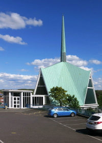
St Andrew’s church was built on a sloping site on Maylands Drive in 1964–5. Nikolaus Pevsner called its origami-style architecture “ingenious, fashionable and slightly absurd.” The granting of parochial status in 1969 was a special concession as Albany Park fell well short of the 10,000 population normally required.
Trees were planted in 2001 on the site of disused allotments between the railway line and the properties on the south side of Canterbury Avenue. Named Millennium Woodland, the area forms an eastern extension of Abbey Hill Park.
Albany Park’s most significant construction project in recent years has been Belgravia Homes’ Cedarwood Place, an apartment block (plus a convenience store) that has replaced the former shops of Norman Parade, opposite St Andrew’s church.