Hillingdon
Hillingdon, Hillingdon
A much-extended village, plentifully endowed with open spaces, situated midway between Hayes and Uxbridge

As befits a settlement that has given its name to the modern borough, Hillingdon has a long history. Once occupying a clearing in the dense woodland that covered the area, its name probably referred to ‘the hill of a man called Hilda’, although others have construed it as ‘the fort on a hill’ and cited dubious stories of a battle in which the Mercians defeated the West Saxons.
The church of St John the Baptist was in existence by 1100 and parts of the present structure date from the 13th century. The road to Oxford, which runs north-westwards through the middle of Hillingdon, divided the uncultivated north from the fertile south, where most of the early farms and dwellings were established. Several areas of common land had attracted settlement to their fringes by the late Middle Ages, including Hillingdon Heath, Colham Green, Pield Heath and Goulds Green.
The Red Lion has stood on the green west of the church since the 16th century and Charles I is said to have rested here in 1646. Numerous gentlemen’s residences were built in the southern part of the parish and of the present-day survivors the most impressive are Cedar House (now offices) and Hillingdon Court (now a school).
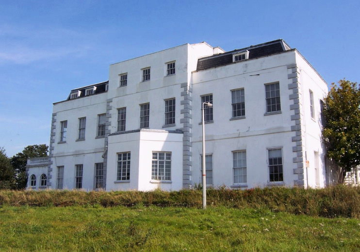
Uxbridge gained economic and administrative ascendancy over Hillingdon and the village languished until the early 20th century, when tram services to London began. In the west, the government acquired the much-rebuilt Hillingdon House (shown from the rear in the photo above) and its grounds in 1915 and established the airfield that became RAF Uxbridge.
After the First World War private developers began to expand the village into a commuter suburb, although many open spaces were retained as playing fields and recreation grounds. The council acquired Coney Green in 1926 and an ancient earthwork was later uncovered here.
The conversion of the main road into a dual carriageway in the mid-1930s coincided with the fullest spate of growth to both the north and south, with the council supplementing the efforts of commercial builders. The new locality of North Hillingdon came into existence at this time.
At Colham Green, post-war council estates greatly increased the population and Hillingdon Hospital was rebuilt in a high-rise design in 1962. The hospital has since been radically redeveloped yet again.
The strength of Uxbridge as a commercial centre has prevented the old village from acting as a focus for the wider suburb, which has had the benefit of preserving some of its charm, despite the intrusion of the busy road.
RAF Uxbridge closed in 2010 and the site is presently being redeveloped as St Andrew’s Park. Hillingdon House may be converted into a restaurant, with office space above. The RAF station’s ‘Battle of Britain Bunker’ is open to the public.
Mary, Marchioness of Rockingham died at Hillingdon House in 1804. Her husband, whom she had married at the age of 16, served as prime minister in 1765–66 and again in 1782, when he died in office.
The astrologer and Middlesex campaigner Russell Grant was born in Harvey Road in 1952.
