Hither Green
Hither Green, Lewisham
A part-gentrified satellite of Lewisham, situated south-west of Lee and east of Catford

In the Middle Ages this was the location of the significant hamlet of Romborough, but it seems likely that the whole population – and the place’s very identity – was wiped out by the Black Death.
After its woodland was cleared in the early 1600s this became an area of nursery gardens and, from the 1780s onwards, of prosperous merchants’ villas. Hither Green’s present name was coined around that time.
An old meaning of ‘hither’ was ‘being on the near or adjacent side’, so the name distinguished the new settlement – which was nearer to Lewisham parish church – from Further Green, which was on Verdant Lane. The variant spelling ‘Hether’ has made occasional appearances – and this has led to the folksy use of the word ‘Heather’, for example in Heather Close – but that doesn’t alter the validity of the ‘hither/further’ derivation. The London Borough of Lewisham’s coat of arms includes heather-coloured (‘purpure’ in heraldic terminology) elements in honour of Hither Green, which is merely a heraldic pun.
A station and a fever hospital opened at Hither Green in the 1890s. The former stimulated the construction of housing for artisans and the middle classes and the latter scared away the rich.
Nearly 3,000 homes were built from the turn of the century until the outbreak of the First World War by Cameron Corbett, who also developed Seven Kings and Eltham Park. The dwellings varied in scale from modest terraced houses to superior detached properties. Although the estate was short on amenities, Corbett’s negotiation of cheap railway season tickets for the residents ensured its success.
The Chiltonian biscuit factory operated near the station from 1911 until 1925, when the business moved a short distance east to neighbouring Lee.
After the Second World War the council erected blocks of flats on estates like Hether Grove, but many of these have already been replaced, mainly because of their poor standards of construction.
In 1960 a rail freight depot opened south of St Mildreds Road, handling at its peak over two million tonnes a year of continental fruit and vegetables. In November 1967 a train derailment at Hither Green cost the lives of 49 people.
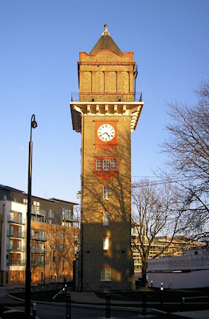
Following the closure of Hither Green Hospital in 1997, its site was redeveloped in two stages: first on the west, mostly with compact houses, then on the east with a dense network of low-rise apartment blocks named Meridian South (because it’s located due south of Greenwich Observatory). The hospital’s clock-faced water tower was retained as a focal feature, and is shown in the photograph above.* Immediately north of Hither Green station, Bellway Homes have recently built apartments, studios and 3‑bedroom townhouses on the site of the old biscuit factory.
