Hook
Hook, Kingston upon Thames
A suburb filling most of the area between Chessington and the southern side of Surbiton

The locality’s name probably refers to a hook-shaped spur of land, although the 12th-century presence of John Hog, a mill owner later known as John del Hoc, has prompted some alternative etymological theories. Hook was earlier called Grappellingham, which mutated into Grapsome.
The first cottages in Hook probably clustered near what is now the junction of Hook Road with Mansfield Road (at the bottom of the map below), when this was the southern edge of Surbiton Common and belonged to Merton Priory.
The common was to remain sparsely populated until the coming of the railway, so Hook’s smallholders and craftsmen had to travel to Kingston to sell their wares. The hamlet’s growth was constrained by the borders of neighbouring estates and it was many years before the population rose above a hundred, inhabiting about 20 dwellings.
In the early 19th century road improvements, enclosure and the sale of land by Kingston council led to a modest surge in Hook’s growth as City merchants built villas here. St Paul’s church was consecrated in 1838.
During the mid-19th century, building societies bought land here and broke it up for sale in smaller lots, often to help their shareholders qualify for the vote. Late in the century Hook became caught up in the rapid expansion of Surbiton as a railway suburb, a process that reached its apogee after the opening of the Kingston bypass in 1927. The largest project was the Hooklands estate of nearly 300 houses with attendant shops. Other roads were developed piecemeal by a variety of local builders.
After the Second World War the last fields disappeared beneath blocks of council flats, except for some playing fields close to the bypass, while most of Hook’s remaining older villas were replaced with more compact dwellings and additional rows of shops.
Opened in 1960, the Hook underpass, which cut through the Southborough locality, was one of the first such projects in the country. On the eastern edge of Hook an industrial and commercial zone has grown from a nucleus of wartime factories on Cox Lane.
Kingston council’s Hook Centre opened in 2006, replacing a former library and community buildings on Hook Parade.
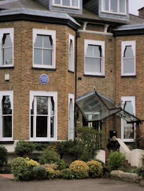
The children’s author Enid Blyton honed her craft while working as a nursery governess at Southernhay, 207 Hook Road, which is shown in the photograph above right. After the success of her first book she quit to take up writing full-time. The house has since been subdivided.
Postcode area: Chessington KT9
Population: 8,741 (Chessington North and Hook ward, 2011 census)
Further reading: Mark Davison, Hook Remembered, Mark Davison, 1997
and Marion Cicely Bone, The Story of ‘Hook in Kingston’, The Parochial Church Council of St Paul, Hook, 1989