Plumstead
Plumstead, Greenwich
A Victorian outgrowth of Woolwich – and nowadays a multicultural community

This place where the plum trees grew was first recorded around 970 as Plumstede. It is possible that the Romans planted orchards here on an agricultural scale.
The present St Nicholas’ Church was built in the 12th century and given an incongruous tower in the early 1660s. The village was of little consequence at this time and remained so until the early 19th century, with scattered farms and minor country houses and a high street that stretched thinly towards Woolwich. The largest landowner was the Pattison family of Burrage House, which lay on the western slope of Plumstead Common.
The Pattisons sold a sandpit as the site for Woolwich Arsenal station, which opened in 1849 and brought the first growth to west Plumstead. Keen to profit further from their property, the family sold Burrage House too, which was demolished so that the railway could be extended onwards into Kent.
To the south of the railway, Burrage Road was laid out and the first terraces of Burrage Town were built on Sandy Hill Road for workers at Woolwich Arsenal. Superior houses meanwhile began to appear on Plumstead Common Road.
The enlargement of the arsenal as a result of the Crimean War and the opening of Plumstead station in 1859 sparked an explosion of growth across the district. The Herbert estate was laid out north of Shooters Hill but Queen’s College, Oxford, was stymied in its attempt to cover Plumstead Common with a high-class development. Almost all the rest of the district was covered with housing and attendant amenities before the end of the 19th century. Former chalk mines west of Wickham Lane were built over in the early 20th century, but some properties later collapsed and the London County Council had to fill the mines with fly ash to prevent further subsidence.

The downsizing of Woolwich Arsenal after the First World War brought decline to Plumstead and its population fell by almost 10,000 in the 1920s. Many of the departing residents did not move far; this was a period of massive growth in neighbouring districts like Welling and Eltham.
After the Second World War council projects transformed the western side of Plumstead. The largest of these was the Glyndon estate, with almost 2,000 dwellings, which was begun in 1959 and not completed until 1981 and has recently undergone regeneration.
Woolwich Mosque was built on Plumstead Road in 1996. The Pashupatinath Mandir and Nepali community centre became Europe’s first Shiva temple when it opened on Swingate Lane in 2007.
In addition to the grade II* listed church, Plumstead’s landmarks include the following grade II listed buildings:
- The Plume of Feathers public house, 282 Plumstead High Street (early 18th century with 19th century alterations)
- Former electricity generating station, subsequently council depot, White Hart Avenue (1903)
- Plumstead library, 232 Plumstead High Street (1903–4)
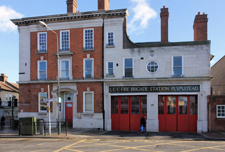
- Plumstead fire station, 1 Lakedale Road (1907)
There are others in the vicinity of Plumstead Common, most importantly Berthold Lubetkin’s grade II* listed houses on Genesta Road.
According to the 2011 census, 44 per cent of the population is white (down from almost two-thirds in 2001). All the major ethnic groups are well-represented, and Plumstead has London’s largest Nepalese community.
