Keston
Keston, Bromley
A dispersed, semi-rural village situated south of Bromley and two miles west of Farnborough

It has been claimed that Keston’s name relates to Julius Caesar’s supposed presence in the area in 55bc. This is extremely implausible, although it is likely that Romans settled here around ad200 and relics of a Roman cemetery have been found. However, the place name probably derives from Old English – ‘boundary stone [stān] of a man called Cyssi’ (no relation to Caesar).
The first reference to the place’s existence appeared in an Anglo-Saxon charter of 862, making this one of the earliest recorded geographical names in the London area. It was spelt Chestan in 1086 (Domesday Book) and Kestan in 1205.
The ancient parish church, opposite the western end of Downe Road, was the centre of medieval Keston but after the Great Plague development began anew a mile and a half to the north, in a clearing between Hayes Common and Keston Common. The latter was one of the first pieces of common land to be protected by Act of Parliament from further encroachment (in 1865) and now has perhaps the most diverse range of habitats of any common in London, with the greatest number of rare species.
Most of the 20th-century construction is hidden from the main roads, including the 140-acre ‘gated community’ of Keston Park, which was begun in 1923 and continues to evolve, ever more expensively. The concealment allows Keston to maintain the impression – by London standards – of an unspoilt rural community.
However, the village has relatively few houses of any serious antiquity or architectural merit. Keston Court, Leafy Grove House and numbers 1, 2, 31, 32 and 33 Commonside are the only grade II listed homes. The smaller village of Leaves Green, to the south of Keston, has more listed properties than this.
The surrounding farmland is littered with evidence of Neolithic as well as Roman occupation, and there is a grade I‑listed, weather-boarded windmill dated 1716, and restored in 1913 – but most of these sites are inaccessible to the public.
Shown in the photograph at the top of this article, Keston Ponds, near the private estate of Holwood, are fed from the fancifully named Caesar’s Well, the source of the River Ravensbourne.
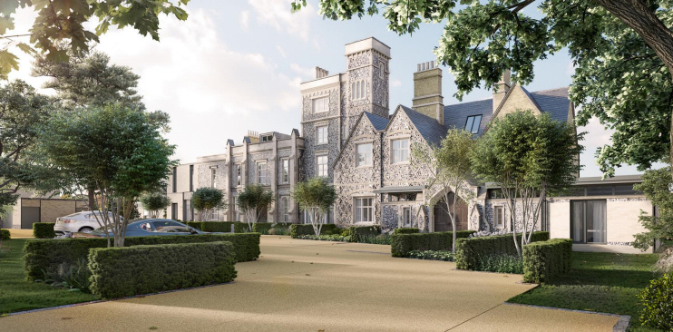
Ravensbourne House, a locally listed Victorian mansion that had been serving as a business centre, was converted into seven apartments in 2017–18. The conversion is shown in the developer’s CGI above. Two pairs of houses were also built in the grounds. The scheme boasts “a secure Club Room” that seems to consist of little more than a boot room and dog wash facility – but these could be useful with Keston Common and the ponds close by.
Postcode area: Keston, BR2
Population: 16,730 (Bromley Common and Keston ward, mid-2016 estimate – barely showing any increase on 2001, an extreme rarity in London)
Further reading: Edward Williams, Keston Parish Album: a History in Photographs, self published, 1984
Website: Friends of Keston Common